Red Bank, Tennessee, is a small city of about 12,000 people, surrounded by Chattanooga. At around 70 years old, Red Bank is working to make its streets safer and more walkable for everyone.
Mayor Stefanie Dalton is a 2025 America Walks Walking College fellow. Made possible through the generous support of the United States Centers for Disease Control and Prevention’s Active People, Healthy Nation℠ initiative, the Walking College is an online education program that connects and supports community champions working to expand access to safe and inviting places to walk.
Note: This interview has been edited for brevity.
Q: You’re a resident of Red Bank, and you were recently elected mayor. How does your experience as both a resident and an elected official affect your perspective on the importance of walkability, road safety, and transportation planning?

A: I moved to Red Bank in 2010, so I’ve been a resident much longer than I’ve been a commissioner/mayor. In that time, I’ve lived in north Red Bank where we have almost no infrastructure for anyone other than motor vehicle users. The only stretch of sidewalk we have is about a 900-foot stretch along Dayton Blvd in front of a subdivision. That sidewalk exists because before I got elected in 2020, I worked with a couple of other commissioners to ask the developer to add a sidewalk — in Tennessee, we are preempted from requiring sidewalk installation with new developments, but we can ask. Unfortunately, it connects from nowhere to nowhere, but it’s a start.
I’ve always lived in the most neglected part of Red Bank, so I’ve been hyperaware of the lack of safely accessible multimodal routes that connect us to the rest of our city. There is no reason for this lack of connectivity, since we have one long, flat arterial (Dayton Blvd) that runs the length of our city. Underinvestment is a chronic issue throughout the entirety of Red Bank. We have a disconnected sidewalk network in central and south Red Bank, which forces non-vehicle users to zig-zag across the five-lane road that is Dayton Blvd and use crosswalk islands that don’t feel safe because vehicles are speeding by at 40-50+ mph across four lanes of traffic. We also do not have bike lanes, and some heavily-trafficked intersections still suffer from decades-old bad design.
When I think of my neighbors who don’t have cars, who are unable to drive, who want to bike to work or school, or who just want to walk/roll throughout their community in a safe, connected way, I feel compelled to do everything I can to make that a reality. I do not consider myself to be even close to an expert on these issues, but I am an attentive and passionate advocate for safer communities. That probably comes from my background as a social worker. In fact, I consider the work I’m doing as an elected official to be community social work. I’m just trying to do my part to make this community safer while empowering my neighbors to advocate for the things they want and need.
Q: How has participating in the Walking College changed your approach to walkability work?
A: The biggest impact the Walking College has had on how I approach walkability work has been through my connections with my cohort, my group, my mentor, and with the multitude of resources provided by the organization. Especially around the particular issues related to my street reimagining project and my Active People Healthy Nation Action Plan, I have learned about so many potential quick/tactical improvements my city can make to increase safety and accessibility. For example, we have a rather dangerous intersection along a road that connects between Red Bank and Chattanooga but is situated in a residential setting; my group and mentor offered up a slew of suggestions to help improve visibility and safety, like rumble strips, painted crosswalks, delineator posts, restriping for shoulder access, a roundabout, and more. The second biggest impact has been with regard to the public narrative piece. As an elected official, I tend to hyperfocus on data to support decisions we make for our community, but the storytelling piece is equally, if not more, important. The introduction to Marshall Ganz’s approach to community building and buy-in through public narratives has been so informative and inspiring.
Q: Red Bank completed its first-ever comprehensive planning effort. What was that process like, and what were the results?
A: We worked hard to make this happen from the day I got elected in 2020, but it took a while to get all the pieces in place. I am so proud that we were finally able to adopt this plan early in 2025!
The plan ended up being an almost 18-month long process, because we were committed to community engagement being the driving force behind the plan. From our first community engagement opportunity on December 1, 2023, to adoption on June 17, 2025, the city hosted seven community engagement opportunities at festivals, open houses, and workshops. Each event was interactive, with story boards, maps, post-it notes, worksheets, comment forms, and open discussion. This was in addition to online and paper surveys we put out to the public in both English and Spanish, as well as stakeholder interviews and an internal steering committee. Our planning consultant was in lockstep with the city and took daily feedback on how to better present visual elements, tell stories, and foster conversation.
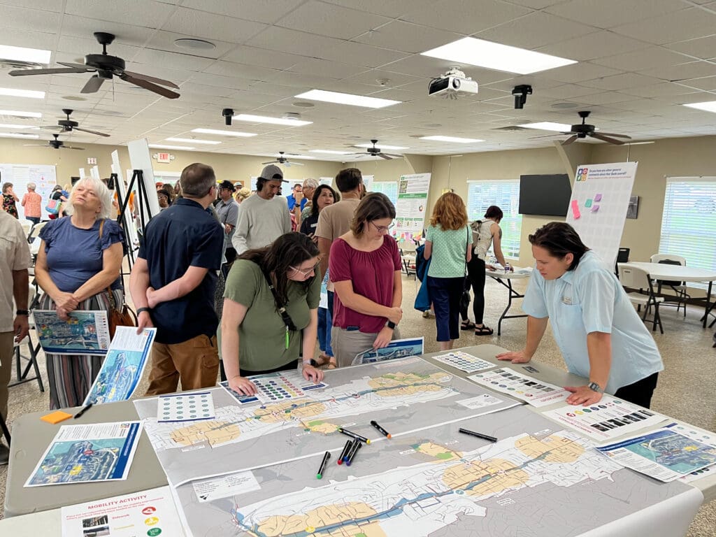
Over the entire course of the community engagement period, we had thousands of participants and often exceeded average response numbers in relation to the size and population of our city (another proud moment!). The finished product is a community-informed plan for our future that identifies our priorities, goals, and an implementation matrix with associated costs, funding opportunities, and timelines. The implementation matrix is one of my favorite parts of the plan because it is fully transparent and creates accountability for those of us responsible for follow-through. Unlike what you see sometimes in other governmental organizations, Red Bank is not here to “check a box” and then stick these plans in a drawer; we are here to do the work of our community for our community.
The Community Development page on our city’s website includes links to the Red Bank Comprehensive Plan 2045, as well as a StoryMap that details the planning process
Q: How has community engagement impacted walkability planning in Red Bank?
A: Interestingly, Red Bank completed a “strategic agenda” report in 2003, which included a small number of community members’ feedback. Even back then, our neighbors were asking for more sidewalks, bike lanes, and improved connectivity. Unfortunately, there was almost zero follow-through on those desires.
More recently, community engagement has impacted walkability planning in Red Bank. When I knocked on my neighbors’ doors in 2020, and again in 2024, I heard over and over again the strong desire of our community to have additional safely-accessible connected routes throughout our city. Our demographics have changed quite a bit in the past 20 years, so it’s very validating to hear across generations how our neighbors want to safely move through our city using all modes of transportation.
With this feedback, we’ve been able to more intentionally focus our planning efforts around multimodal routes. In fact, Red Bank has passed resolutions committing to Trust for Public Land’s 10-minute Walk to a Park initiative, as well as the CDC’s Active People, Healthy Nation approach to improving community health outcomes. Additionally, our Complete Streets policy is currently in development.
If we did not have the support of our community for these types of initiatives and approaches to planning, we would not be where we are today — on the heels of the adoption of our first-ever comprehensive plan and on the cusp of tangible change!
As an example, we have had a resurfacing/restriping project in north Red Bank in the queue for over five years. There are often slow timelines when you are dependent on your state DOT for grants, but this has actually been a blessing because we now have elected leadership and staff who are responsive to the desires of the community. This engagement enables us to change the restriping plan to right-size this section of Dayton Blvd, which will open up shoulder access for non-vehicle users where none currently exists. It will also allow us to plan for future sidewalk and bike lane installations.
Q: What are some of the barriers you’ve come against in doing this work?
A: We’ve encountered an assortment of barriers, ranging from minor to majorly challenging. One example of a more minor barrier has been some of the more technical and/or nuanced language used to describe walkability and accessibility improvements, such as multimodal, traffic calming, desire paths, right-sizing, leading pedestrian intervals, etc. So, we’ve had to make some extra efforts to define and educate our neighbors on what these mean and look like in real-life scenarios. The saying “a picture is worth a thousand words” really rang true when our community planner created a video and visual mapping elements to help educate the public on an upcoming right-sizing/resurfacing/restriping project. We talked all day and night about this project, but it didn’t really resonate with our neighbors or give them a helpful understanding until they could see it and hear it explained through these visual aids.
A couple of the more challenging barriers have been navigating the logistics of retrofitting a car-centric developed community with accessible multimodal infrastructure (and the associated costs), as well as pushback from some residents over talks of “reducing a lane here” or “adding a bike lane there.” Understandably, change can create a very emotional response in folks, especially when they presume that that change is going to inconvenience them. But now that I’ve gotten a good introduction to Marshall Ganz, I’m hoping to be able to use that public narrative piece to engage with and have productive conversations around issues like this!
No matter the challenge, the safety and well-being of every single one of our neighbors is at the forefront of everything I do in my elected role. At the end of the day, I will always make decisions that reflect those values.
Q: What have been some of the successes?
A: Oh, so many! We have kind of had an embarrassment of riches these past few years since I’ve been in office, for which we are so thankful. We’ve won hundreds of thousands of dollars in grants for things like a community mobility study, a right-sizing study of Dayton Blvd (ultimately proving to be feasible in line with TDOT and traffic engineering guidelines), sidewalk additions, and ADA improvements, on top of the budgeted improvements we’ve been able to make toward traffic calming, safer crosswalks, and upgraded school zone design to enhance visibility and safety for our children.
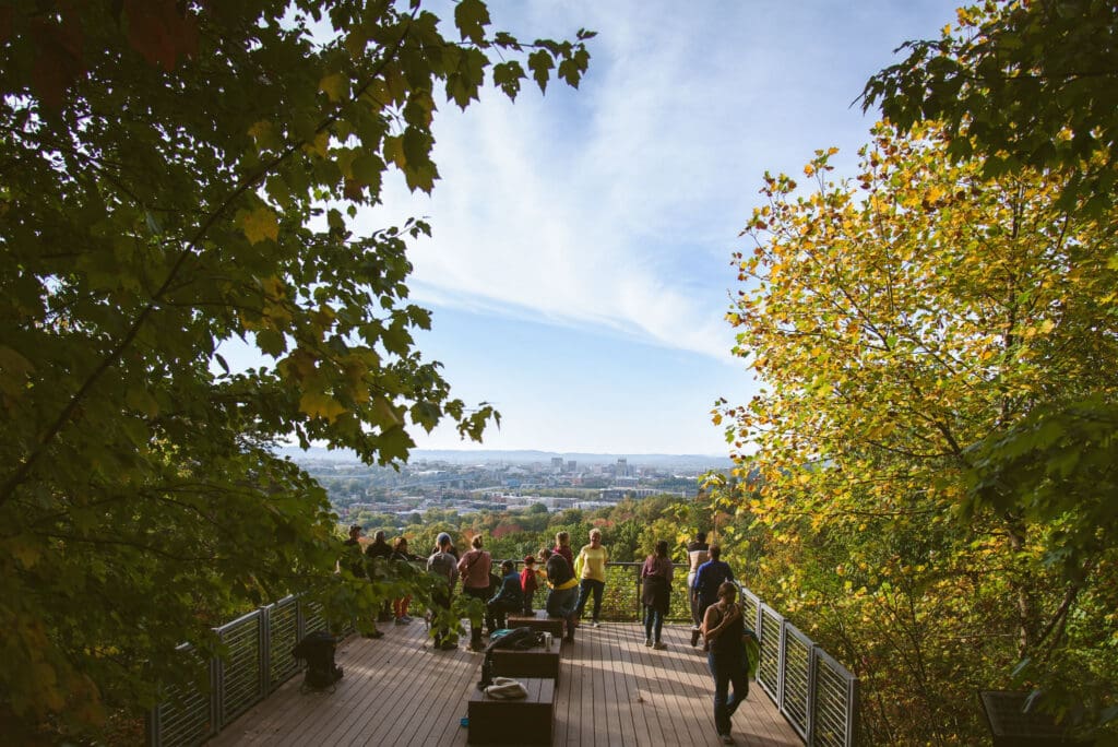
Not only have we adopted our first-ever comprehensive plan, we’ve also adopted our first-ever Parks & Recreation Master Plan; created a Department of Community Development to focus on comprehensive planning, zoning, and land use; completed our first-ever sidewalk inventory; completed a connector trail that ties into a much larger trail system into Chattanooga; received a $400,000+ non-matching grant for a new multi-use trail system that will also cover new sidewalks, crosswalks, and ADA upgrades; implemented new right-sizing restriping/resurfacing plans with existing queued projects on both the north and south ends of Dayton Blvd; and so much more.
None of these accomplishments would have been possible without the engagement and support of our neighbors. Truly, our successes are dependent on folks showing up, engaging, volunteering, and leading the way towards our shared future — and my Red Bank neighbors keep doing just that.
Q: Your planning project for the Walking College focused on Appian Way. What is the significance of Appian Way to the community, and what changes are you working to implement?
A: For me personally, Appian Way is a road I travel daily. It connects Dayton Boulevard to Chattanooga and runs through an almost entirely residential area in Red Bank. One of the residential roads off of Appian Way connects to a dead-end street where the only elementary school in Red Bank city limits and a church are located. One particularly dangerous section along Appian Way is a four-way stop featuring a non-linear crossover street and limited visibility due to the curvature and slope of the road, as well as a retaining wall on one corner. This section of the road is in a school zone.
There are no sidewalks or crosswalks on Appian Way. There isn’t even a shoulder for non-vehicle users to use. I personally have witnessed people speeding on Appian Way, both up- and downhill, and often flying through the four-way stop without so much as a passing glance. These dangers make this road truly unsafe for anyone, let alone children, to travel on it. Even being in a car feels dangerous when other drivers regularly speed and blow through the stop signs. I’ve had many conversations with our staff about this road, and one of the first things we’re going to work on is improving the four-way stop, which may include relocating and repainting stop bars, installing rumble strips, and adding flashing LED lights to the stop signs.
We also are developing a Complete Streets policy, which I have asked to include policies around safe routes to school. To paraphrase Gil Penalosa, if we’re not making our streets safe for 8-year-olds and 80-year-olds, then no one’s safe. And everyone deserves to be safe however they need or want to access our streets.
This publication was made possible by the Centers for Disease Control and Prevention (CDC) (Contract #47QRAA20D003W). Its contents are solely the responsibility of the authors and do not necessarily represent the official views of CDC. These efforts are part of the CDC’s Active People, Healthy NationSM Initiative that is working to help 27 million Americans become more physically active by 2027.