When we think about making our communities more walkable, we often focus on streetscape improvements, like wider sidewalks, better crosswalks, and trees. But what if the biggest barriers to walkability aren’t at street level at all? What if they’re buried in our zoning codes and land-use regulations?
Architect Cary Westerbeck, developer, and planning commissioner for Bothell, Washington, joined America Walks Executive Director and former Mayor of Seattle, Mike McGinn, during a webinar to make the case for why land-use matters just as much as street design when it comes to walkability.
Why Land Use Matters for Walking
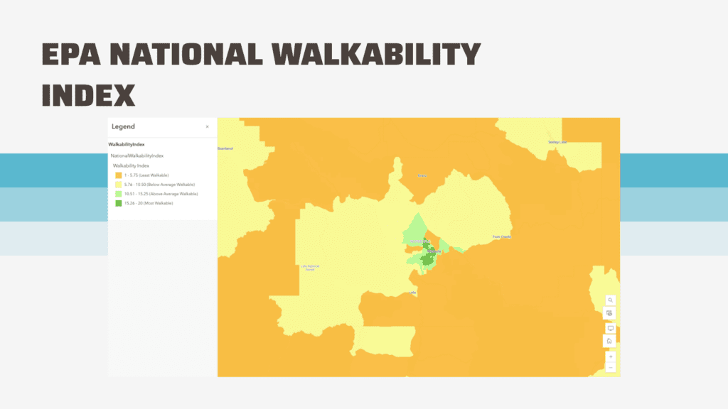
How much people walk is correlated with the land-use attributes of where they live. Tools like Walk Score and the Environmental Protection Agency’s National Walkability Index use real data to rate walkability in towns and cities across the country. Over and over, the most walkable places are often due to those better land-use policies and practices.
Dr. Lawrence Frank, America Walks board member, has been quantifying the connections between built environment, active transportation, and health outcomes. In a 2006 study on Many Pathways from Land Use to Health, Frank and colleagues found that a 5% increase in walkability was associated with a 32.1% increase in time spent in physically active travel.
Three primary land-use factors drive walkability:
- Mix of uses and housing density: When homes, shops, offices, and services are close together, walking becomes practical
- Distance to transit stops: Transit serves as the middle leg of walking trips
- Intersection density: A connected street grid dramatically expands how far you can walk
Consider this striking comparison: in a traditional street grid, you can walk much farther in the same amount of time compared to a sprawling suburb of cul-de-sacs. One analysis of St. Mary’s County, Maryland found that walking from one cul-de-sac to a neighboring one — just backyards apart — would take 54 minutes and cover 2.4 miles, because residents must navigate out to arterials and around.
Places vs. Non-Places
Urbanist Andrew Price popularized the idea of Places and Non-Places for Strong Towns. Places are built for people: homes, shops, parks, and human-oriented streets with names and purposes. Non-places are the spaces in between: wide roads, freeways, parking lots, and generic landscape buffers that nobody actually uses.
As Price explains: “By creating a Place:Non-Place map of our own cities, we can get a good idea of how much land is sitting underutilized.” His analysis found that in some sprawling developments, over 10 times more land is dedicated to non-places than places, a pattern that makes walkability nearly impossible and raises serious questions about financial sustainability.
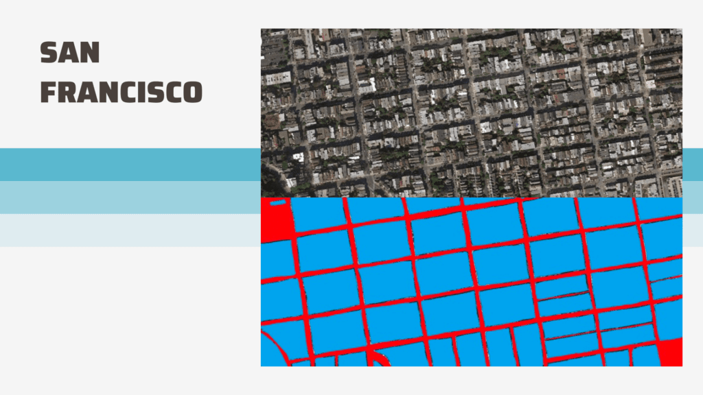
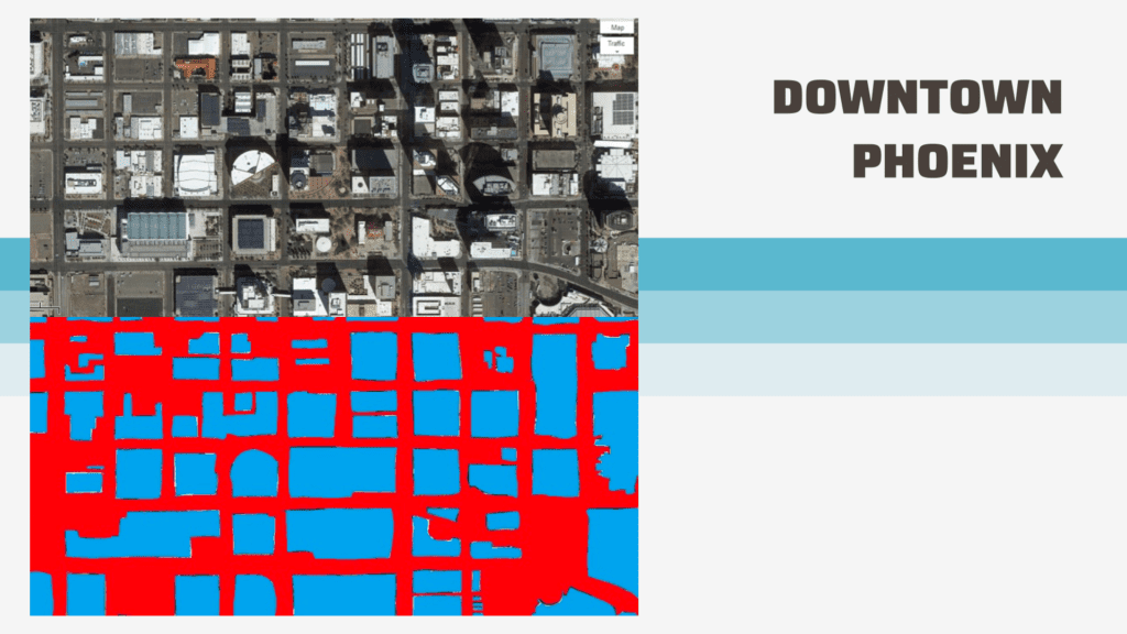
Looking at maps through this lens reveals the problem. San Francisco: very placeful. Downtown Phoenix: dominated by parking lots that separate everything. Typical suburban development: non-walkable roads connecting isolated destinations.
5 Land-Use Policy Changes That Enhance Walkability:
1. Reduce or Eliminate Parking Minimums
Parking minimums make housing more expensive, force destinations farther apart, aren’t based on actual need, and can even prevent small businesses from opening. Cities across the country are eliminating these requirements and already seeing the benefits.
McGinn shared an example from his own Seattle neighborhood of Greenwood: “Behind that wall was a parking lot. Just removing the requirement for parking minimums means that parking lot was turned into outdoor seating, the wall was reduced in height, and this is now a more inviting walkable place.”
2. Allow Mixed Uses
“Before we had zoning codes that separated uses, we just naturally built places close to each other,” McGinn noted.
Single-use zoning — separate zones for offices, retail, and housing — forces people to travel via motorized vehicle between the different parts of their daily lives. Allowing corner stores in residential areas, home-based businesses, and mixed-use buildings brings destinations closer together.
3. Legalize More Housing Types
Missing middle housing, including backyard cottages, townhomes, and small apartment buildings, can easily fit into neighborhoods and increase density without changing their character. These housing types were once common but have been illegal in many areas for decades.
4. Connect and Right-Size Streets
By “right-sizing,” we mean tailoring streets to meet the needs of those living and traveling on them. Often, zoning codes require wider streets and driveways based on building use or size, and for emergency vehicle access. These streets tend to be less safely walkable for pedestrians.
Similarly, building connected streets helps support physical activity by providing pathways for walking, rolling, and biking.
This principle isn’t only for urban grids; smaller towns desiring to make their Main Street more vibrant can set land-use policies in motion that enable safer, slower streets that allow residents to access the social and economic life of their community.
5. Prune Unneeded Regulation and Expedite Infill Development
Is new housing treated as a community benefit or a problem to mitigate? Excessive setbacks, lengthy review processes, and regulations designed for large projects but applied to small ones all slow down the creation of walkable neighborhoods. There is a lot more nuance here, but moving projects through the application process efficiently reduces costs and helps create the housing communities need.
Real-World Examples
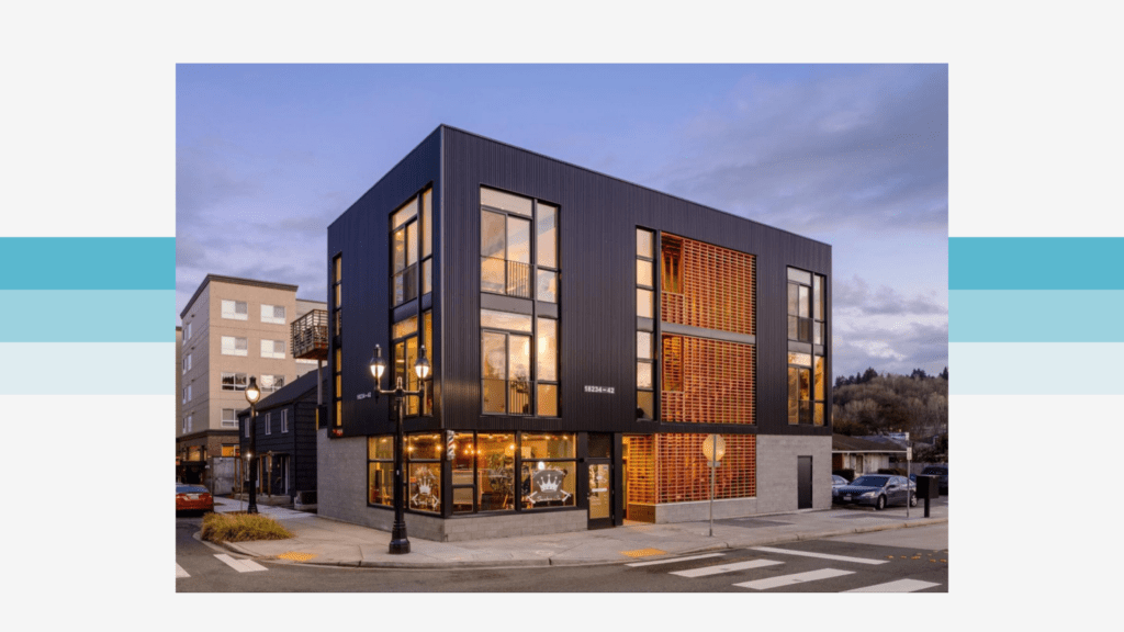
Westerbeck has brought these principles to life through his own development projects in Bothell, Washington. His Fir Street Flats—built on just 2,600 square feet of land—includes four residential units with a barbershop at street level. The building has become beloved in the community, with people doing photo shoots there.
The City of Bothell has been transformed by eliminating downtown parking requirements, closing Main Street to traffic to promote walkability, and updating codes to require buildings close to the street with entrances, not driveways, that face the sidewalks.
Getting Started in Your Community
Building consensus for these changes isn’t always easy, but conversations about housing, affordability, and pedestrian safety are happening in communities around the country.
So, How can you get involved?
“You really have to start showing that there is public demand in the community,” advised McGinn. “Go out and meet people, talk to people, and find allies.”
Westerbeck emphasized that smaller cities often have an advantage: “You can actually do more faster often by digging in and getting to work in those smaller cities. It’s a lot harder to move the needle in Toronto or Seattle or Los Angeles.”
The Bottom Line
As Bothell Mayor Mason Thompson has said: “You get what you build for.” If we intentionally build people-friendly places through mixed uses, connected streets, and flexible regulations, we will get the safe, healthy, walkable places that many people want.
For more, watch the whole webinar here!
Additional Resources
Research and Data
- Dr. Lawrence Frank’s research on walkability and health: Many Pathways from Land Use to Health (2006)
- EPA National Walkability Index
- America Walks webinar: The Land Use/Walkability Connection with Dr. Lawrence Frank
Planning Frameworks
- Andrew Price: Places and Non-Places –Strong Towns (2014)
- Parking Reform Network – Resources for eliminating parking minimums
- Jeff Speck: Walkable City – Comprehensive guide to walkability principles
This webinar was funded by the Centers for Disease Control and Prevention through their Active People, Healthy Nation program.