Our January webinar “Planning for Walkability Is Planning for Health” featured Dr. Lawrence Frank, an expert on the connection between walkability and health. Decisions made about transportation at the systematic level often focus on the speed and quantity of people moved as the primary metrics for judging outcomes, which misses the significant impacts of those decisions, including health, climate, and local economies.
The webinar, made possible by the Centers for Disease Control’s Active People, Healthy Nation initiative, underscored the health benefits associated with walkable neighborhoods. Research indicates that individuals residing in walkable areas are more likely to engage in regular physical activity, leading to reduced risk of chronic disease. Walkable communities also promote mental well-being by facilitating social interaction and reducing stress.
Walkability affects pollution too. Walkable places can generate less harmful pollution. But dense housing is often situated next to busy arterials, burdening residents with worse health outcomes for the benefit of those living in single-family homes farther from busy roads or highways.
Street infrastructure isn’t the only element that influences walkability. There’s also land use, the pedestrian environment, and green spaces. Most measures of walkability rely primarily on land-use factors. Data about mixed uses, connected street grids, and residential density are readily available. They’re also highly correlated with the amount that people walk. By contrast, granular knowledge about the pedestrian environment — including sidewalks, seating, lighting, safe crossings, and street furniture — is not readily available, though this is changing thanks to advancements in artificial technology that are enhancing street analysis and allowing for identification of pedestrian features. This information will allow for better research into which features of the physical environment most affect walkability and health.
The Environmental Protection Agency (EPA), Urban Design 4 Health, and others are developing a National Public Health Assessment Model (NPHAM), a tool to understand and forecast future health outcomes from transportation investments. The tool incorporates the National Environmental Database, supported by the Robert Wood Johnson Foundation, which has data on built, natural, and social environments.
NPHAM can be used to introduce health into the transportation planning process by comparing different investment strategies to quantify the dollar impacts of their health impacts.
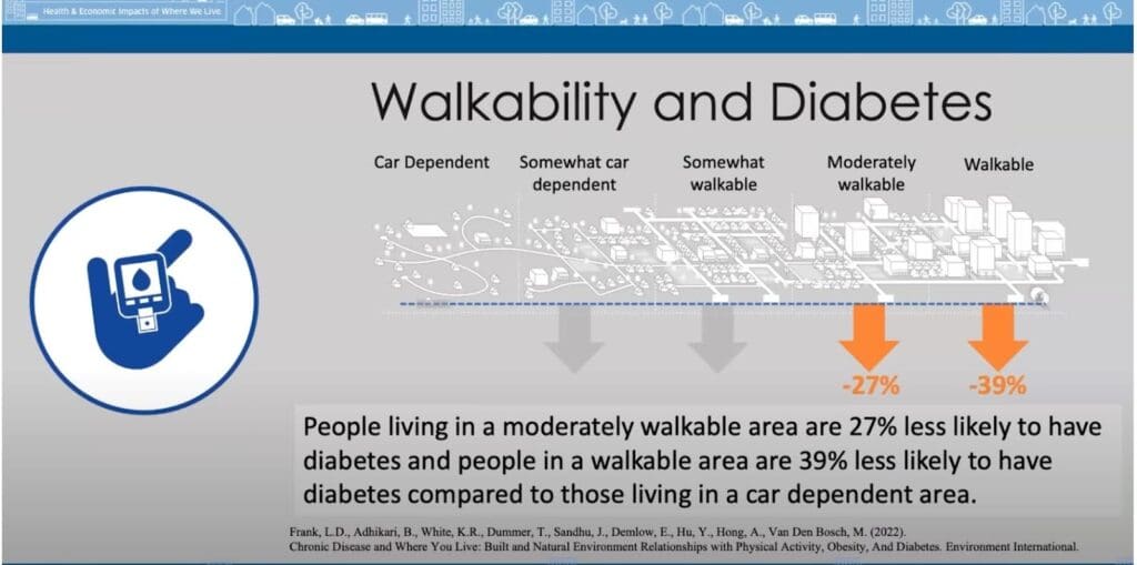
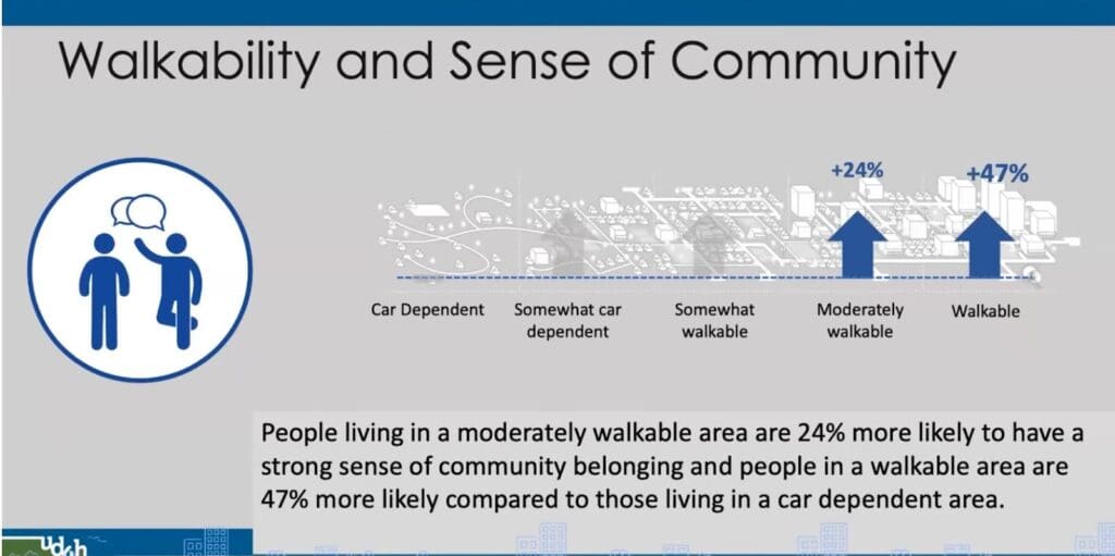
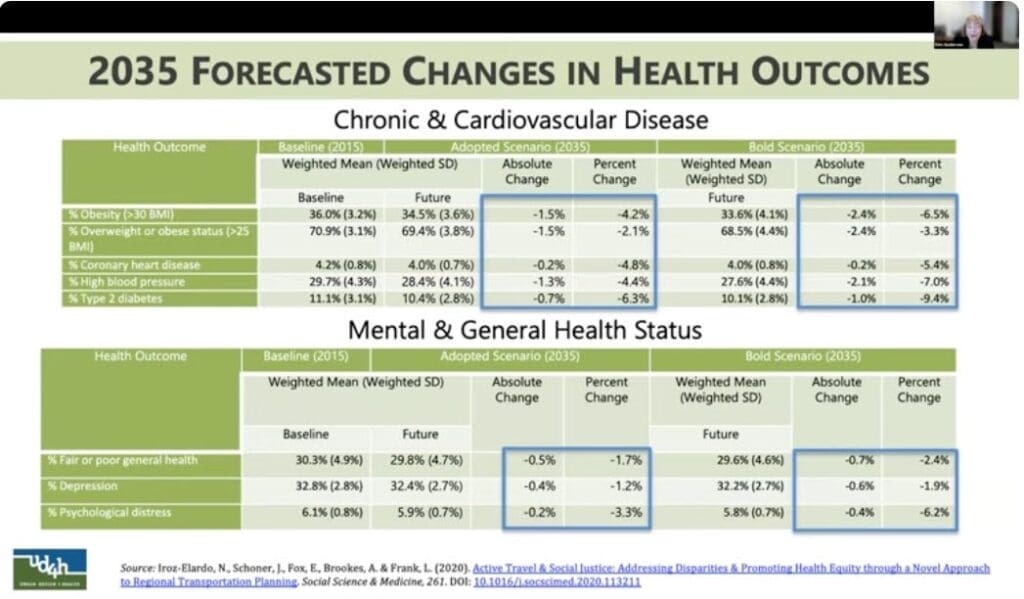
Dr. Frank also shared information about how more walkable places generate better health outcomes for residents, both in fighting chronic disease and combating social isolation.
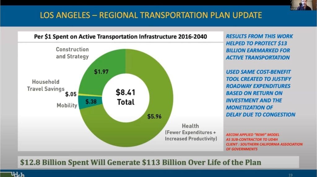
Transportation investments are often justified by their alleged time savings to commuters. Investments in active transportation are typically marginalized for not having a “serious” return on investment. Yet when we quantify actual health benefits, they far outweigh alleged value of time savings. Below is an example of this analysis applied to the Los Angeles Active Transportation plan.
Kim Anderson walked through how the San Joaquin Council of Governments used these tools as a counterpoint to transportation demand modeling. San Joaquin County, California, is mainly rural and bounded by mountains, but includes the urban area of Stockton. The county hosts commuters to the San Francisco Bay Area as well as trucking distribution centers. Although active transportation represented only a small part of the overall transportation budget, the process demonstrated how even a small investment in active transportation can generate outsized health results.
EPA’s Alan Brooks explained the EPA supports NPHAM and the development of scenario planning tools to protect human health and the environment. At this point, the EPA considers NPHAM a mature, peer-reviewed approach to understanding health outcomes from land-use and transportation plans.
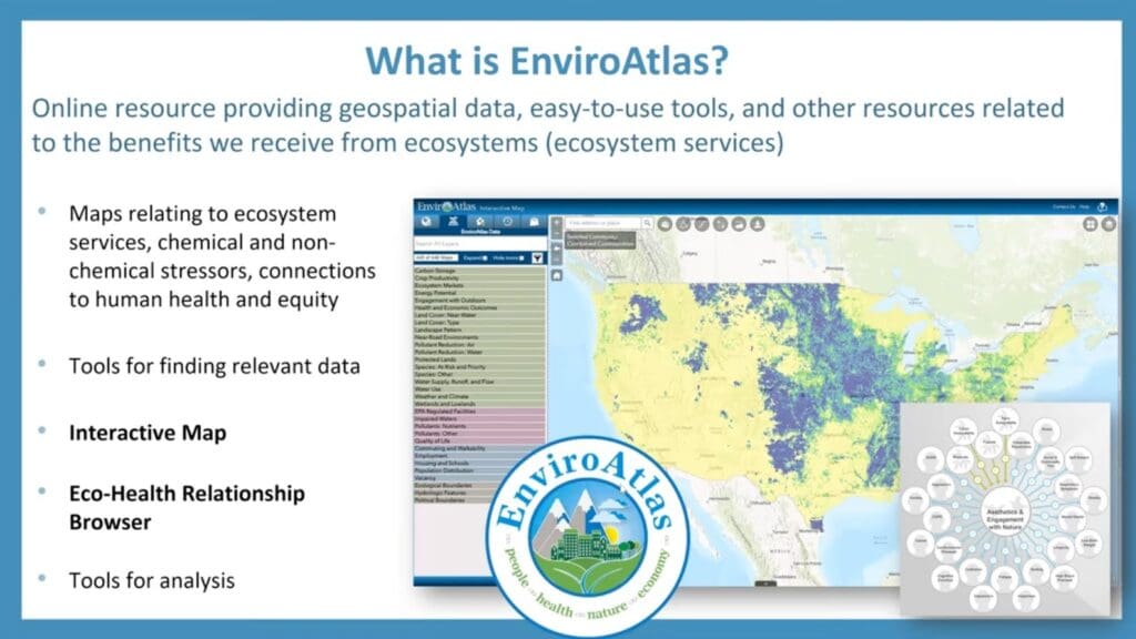
Alan also shared EPA’s EnviroAtlas, which will soon incorporate NPHAM to allow for scenario planning.